Southern Malvern’s walk
28 March 2012
This walk was led by John Payne, and follows on from the lecture he gave to the group on 11 Jan 2012. Click here for a write up.
To view a geological map of the area click here, and set the search box for < Hollybush Worcestershire >.
The walk started at Hollybush car park, grid ref SO758369 (point 1 on the map below).
Map of the walk

Location 2 – The Earth House
The Earth House itself is being built on a small disused quarry on the hills, and was started 12 years ago. For an interesting précis of it see www.underthehollybush.com. The geological interest was a well exposed low angle thrust fault near the far wall of the house. The fault occurred during the late Carboniferous Variscan orogeny, which saw many similar thrust faults across the Malvern Hills. The fault is at 30 degrees to the horizontal and filled with fault gouge. Fault gouge is a fine ground material, similar to a clay, caused by the continuous movement of the fault over time. It is much finer than a fault breccia.

The thrust fault line is clearly visible. Above it is highly rotted Malverns Complex rock, below we have unweathered Malverns Complex rock.
Location 3 - Half way up Raggedstone Hill
We stopped to look out over the Severn Valley. This is a large expanse of mostly flat land, composed of relatively soft rocks, muds and soft sandstones of Triassic age. Beyond the Severn River these red Triassic rocks are replaced by grey, marine Jurassic rocks of a similar composition. In the distance we see the ridge of limestones and hard sandstones of the Cotswolds, again Jurassic. If we were able to see further East, we would see the rocks becoming ever younger and younger. The reason for this progressive aging of the rocks is that they are all slightly dipping to the East. So, on flat land later and later rocks are exposed going down the dip direction. This Easterly dip is believed to have been caused by tectonic activity at the end of the Cretaceous period. This may possibly have been the early stages of the Alpine orogeny.
John pointed out the flat area immediately in front of us. In early Victorian times this was thought to have been a shallow sea, and called “The Straits of Malvern”. This idea was disproved around 1860 and the evidence for it is now believed to be the result of glaciations.
Location 4 – Summit of Raggedstone Hill

The group at the summit of Raggedstone Hill.
John reviewed the formation of the Malvern Hills, in particular their shape. They are a ridge of Precambrian rocks, around 11 km long, running North to South. The hills were thrust up during the Variscan orogeny, and their shape is due to the presence of the East Malvern Fault. This fault was created when two micro-continents merged in Precambrian times, and is at least 200 miles long. Why then did the rocks only get thrust up in the Malvern area? John explained that there are undulations on the fault, meaning that when pressure is applied the rocks can only go in one direction – upwards. This creates a flower structure. At Raggedstone there were probably two distinct sections of rock creating two peaks. Double peaks also occur at Midsummer Hill and North Hill.
We examined some of the rocks on the summit. John pointed out some with a layered structure, a metamorphic gneiss. They were quite light in colour demonstrating that they were rich in quartz. This is quite rare in igneous rocks and it has been suggested that they may be metamorphic Precambrian sedimentary rocks. We also saw some with minor folding
Examining rock at the summit of Raggedstone Hill - a quartz rich metamorphic gneiss.
Now we looked West from Raggedstone Hill and discussed the principal geological features. Again the rock layers were originally horizontal, but were pushed upwards during the Variscan orogeny. Pre ice age there was a major river to the West, the Mathon River, but this was blocked due to the impact of glaciations. Gravel deposits from this river and the glacial lake have been extracted.
Then we discussed the Ordovician and Cambrian deposits. These are in a small area, say 3 km to 1 km square, just South of the Obelisk. These are one of the few Ordovician and Cambrian exposures in England today. John showed us the drawing he used in his earlier talk:
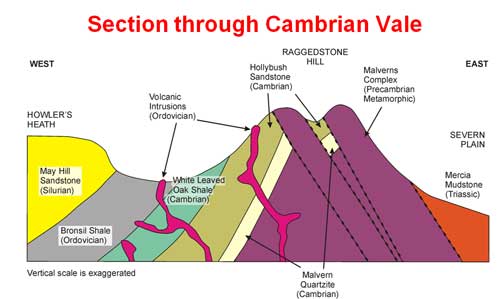
Note the volcanic intrusions of late Ordovician age. This volcanic activity occurred during the Caledonian orogeny. John pointed out a number of the intrusions visible as small tumps on the landscape.
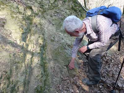
Location 5 – Top of Whiteleaved Oak quarry
The quarry at Whiteleaved Oak is an important geological site, having been the location where two Victorian theories were demonstrated.
The quarry is mainly of Malvernian igneous rock, but there are exposures of Cambrian sedimentary material. The age of the Cambrian rocks was known from the fossils they contained, but in the 1860s the age of the Malvernian was unknown. In addition, it was unsure as to whether the abutment of the Malvernian rocks to the Palaeozoic ones was a fault or an unconformity. This site provided an answer to these two questions. Because pebbles of Malvernian rock are found within the Cambrian sandstone, it follows that the Malvernian is of Precambrian age. In addition, the boundary is an unconformity not a fault as there is no planar junction between the two rocks.
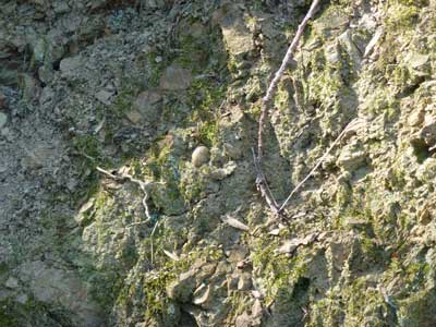
John pointing out an area of Schist within the Cambrian sedimentary sandstones, shales and clay.
John also pointed out some pebble bands forming a quartz conglomerate. It is thought that this represents a transition between quartzite, formed in a shallow sea or beach, and sandstone formed in a deeper sea. This would have occurred in Cambrian times.
Quartz pebble within the pebble band.
The second important discovery at this site is a proof of the theory of dynamic metamorphism. In 1893 Charles Callaway discovered a collection of rocks showing the progression from pure igneous rock to a schist. This demonstrated that tectonic activity could produce a schist in a small area. Previously it was thought that this could only be done through the heat of a magma chamber.
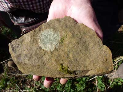
Location 6 – Bottom of Whiteleaved Oak quarry
We moved to the bottom of the quarry and John showed us a sample of a schist in the scree. This was actually a grey chlorite phyllonite (also called chlorite phyllosilicate). This shiny rock contains mica and will laminate along defined planes.

A piece of phyllonite schist from the bottom of Whiteleaved Oak quarry.
Location 7 – Gray’s cottage waterfall
An unusual find here, a waterfall amongst the Triassic rocks. We examined this, a hard rocky ledge above with a soft area below. The ledge is actually a breccia consisting of rocks found in the hills, namely Malvenian, Hollybush sandstone and soft bits of black shale. The breccia was formed at the end of the Triassic when conditions were very dry and arid. The breccia rocks were brought down from the hills as a debris layer and the consolidated into a hard band. Beneath the ledge is a breccia-conglomerate of Triassic mudstone. John told us that we were walking on an exhumed Triassic landscape.
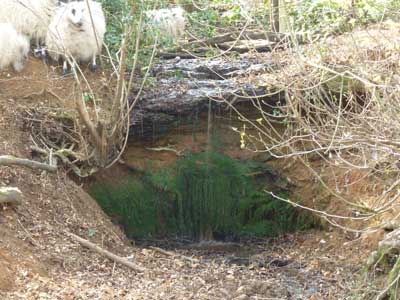
Gray’s cottage waterfall.
Location 8 – Above the bridge
Looking North from this point we see more Hollybush sandstone. This rock is red in colour, this redness is not seen in the sandstone around the Obelisk. John believed the coloration is due to our proximity here to the East Malvern Fault. The fault plane is very close to us, causing red iron compounds to leach out and stain the underlying rocks.
Location 9 - Whiteleaved Oak shale pits
We looked at two shale pits dug along the hedge boundaries of the field margins here. John told us that he thought the first ones were dug in around 2001 in an attempt to find fossils. There are apparently small trilobites in the black Cambrian shale. We moved to the second pit which had a lighter colour of shale. This lighter colour is due to bleaching by the proximity of hot molten intrusions that we were close to. The intrusions are Ordovician dolerite, and are visible as small raised tumps in the ground. We discussed the change in the flora that these intrusions cause.

Cambrian black shale from the first pit area.

The second shale pit.
Location 10 – Ancient tree
We walked West from the shale pits to see an ancient Oak Tree. The tree is estimated to be 400 – 500 years old and appears to be quite well known, with pagan visits and many gifts hung from the branches. It is growing beside another Ordovician volcanic intrusion, this time the rock being spilitic andesite rather than the dolerite we had seen before. These rocks have potassium replaced by sodium, showing that they have been deposited in sea water.

The ancient tree.

Spilitic andesite. From the Ordovicion volcanic intrusion near the ancient tree.
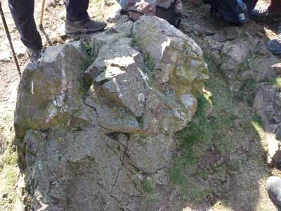
Location 11 – Hollybush quarry
To finish off the day, John took is to the Northern end of Hollybush quarry. One or two brave souls struggled through the brambles to find us an example of Cambrian Malvern quartzite. This concluded an excellent day.
Malvern Cambrian quartzite from Hollybush quarry.